One of the real delights of Exmoor is its smallness. There are not great expanses of similar scenery, it changes at every turn. That is the most common comment I get when guiding around the moor and why I love it so. To benefit the most, clear days are essential.
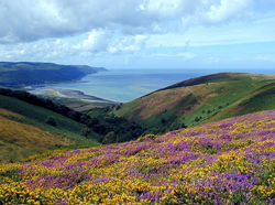
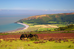 I am going to start with probably the most obvious viewpoint, but that just shows how good it is. There is a free car park at the top of Porlock Hill by a junction called Whitstone Post (OS grid ref: SS 855 462) where a small road goes off the main A39 to Exford. Pull into this car park and looking eastwards the local view is over the beautiful Porlock Vale. The sweep of Porlock Bay, the shingle ridge and the salt marsh behind it is clear to see. On the other side of the vale is Selworthy Beacon coming to a headland at Hurlstone Point. In the far distance, over the beacon you can see the angular structure of the Hinkley Point Power Station on the coast and the Quantock Hills stretching inland from there. On a good day you can also see two islands in the channel, Steep Holm and Flat Holm. Looking straight across the Bristol Channel you are looking at Porthcawl and Swansea in Wales.
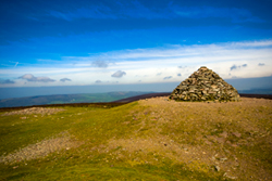 For the grandest viewpoint, it has to be from the highest point on Exmoor, called Dunkery Beacon. The easiest way to get here is to go to Wheddon Cross, on the junction of the A396, Dunster to Dulverton road and the B3224, Exford road. From Wheddon Cross follow the Exford road for 0.7 miles to Blagdon Cross, where a small road goes off ahead as the main road bears left. Follow this small road for 2.6 miles, crossing a cattle grid to continue to a roadside layby (OS grid ref: SS 903 419). The layby itself has impressive views, but not all-round. From here is a fairly easy 0.9 mile walk up to Dunkery Beacon where you will find a cairn. The views are all around. To the north you get a similar view to the previous viewpoint, across the Porlock Vale to Wales. To the east across Exmoor to the Quantock Hills. To the west across Exmoor and North Devon to see Lundy Island out to sea and Hartland Point to its left. And to the south across Exmoor and mid Devon with its patchwork quilt of small fields to the hills of Dartmoor, the more rugged National Park in south Devon.
 My next viewpoint is from Selworthy Beacon. To find this road, go to the shopping centre of Minehead called The Parade. Turn into Blenheim Road at the seaside/eastern end of The Parade. Take the next left into Martlett Road, signed to North Hill. Follow this road uphill and round to the left by the war memorial into St Michael’s Road. Keep following this road as it climbs, leaving the town behind. The road now reaches woodland and goes through a hairpin bend before climbing more steeply on to Selworthy Beacon. Cross the cattle grid and the road starts to level off. There are various car parks along this road and some impressive views as well. But continue along this road to its very end and park there (OS grid ref: SS 910 476). The views from here are spectacular, along the Exmoor coastline and high cliffs. By walking along the track to the right of this car park probably gives you even better views as you walk along it. You are now looking in the opposite direction to the first viewpoint, across the Porlock Vale, but this time giving you a good feel of the height of Exmoor. Dunkery Beacon is to the south of you, a very rounded hill.
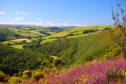 My next choice is County Gate car park on the A39 between Porlock and Lynmouth (OS grid ref: SS 793 486). Here you get two views, a classic Exmoor valley or combe, looking south-west and the Doone Valley looking south-east. The south-west view shows the typical wooded hill, covered in sessile oaks, looking a bit like heads of broccoli in season. Beyond is a wide valley with the East Lyn river in its upper reaches. This valley soon deepens to a steep-sided wooded valley as the river rushes through large boulders, passing Rockford and Watersmeet on its way to Lynmouth. The south-east view looks over Malmsmead, heart of the Doone Valley, looking up into the open moorland and the Badgworthy Water combe. This makes for a lovely walk.
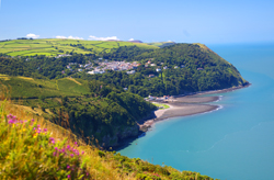 My next choice is from Countisbury, again on the A39 just above Lynmouth, towards Porlock. There is a National Trust car park opposite the Blue Ball Inn (OS grid ref: SS 747 496). Park here and walk up to the small church, worth a visit for itself. Walk through the churchyard to go through a small gate at the back to reach the South West Coast Path. Turn left out of the gate and soon an impressive view opens up overlooking Lynmouth and Lynton and Hollerday Hill as the backdrop. There are some lovely walks around here including the coast path.
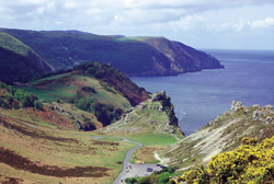 There are so many glorious views that I am sure you will discover yourself, but my last one here is going to be a really unique one and that it the view down the Valley of Rocks. To get to the Valley of Rocks, you need to follow the road out of Lynton westwards towards Woody Bay, ignoring the road to the left towards Barnstaple. This almost level road leaves the village and passes the cemetery on the left to cross a cattle grid. Just the other side of the cattle grid is a layby by toilets and a picnic area (OS grid ref: SS 711 496). Park here and then cross over the road to the Poets Shelter. Walk along the footpath for a great view across probably one of the best-located cricket pitches in the country, for a long view down the valley. Keeping on this path will bring you out to the South West Coast Path. Drop down to it and turn hard left to follow the coast path where it comes back into the Valley of Rocks having given you some more impressive views along the way. For a slightly higher view you can walk up the zigzag path that starts by the shelter and goes up Hollerday Hill.
I hope this has inspired you to discover more of this jewel of a smaller National Park which has so much packed into its small area.
Bryan Cath